Saturday, August 30, 2008

Finished! - 8/20


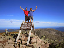
We reached the pier at Bar Harbor around 1pm on August 20th. Bonnie's parents were waiting for us to come in. Of course we had to go down the boat ramp to dip our tires in the Atlantic Ocean, completing our trip. Then we posed with the sign Mike had made, taking tons of pictures while random people came by to congratulate us. We had great weather for our last day. After 4,246 miles and 86 days on the road, we are done!

Crossing to Desert Island


We crossed the bridge at Tremont to Desert Island. We had breakfast at a picnic spot by the water, then crossed the last of the hills towards the finish. We stopped at the Acadia Park sign for a shot, then biked through Bar Harbor to the pier.

Last camping spot


Our last camping spot was not a great one. By the time we finished dinner, light was starting to fade, and we'd missed the turnoff for quieter Rte 233 that our bike maps showed us taking. Instead, we were on busy Rte 3, with suburban sprawl and no good places to camp. We found a pulloff with a small opening, far enough from the highway so we couldn't be seen, but not out of earshot of traffic. We barely had time to set up camp as we lost the last of the daylight. In the morning, we had a number of slugs crawling on our tent.

Almost There - 8/19


We had heavy downpours in the morning. We stopped at a used bookstore, one of our favorite pastimes, to get out of the rain. We crossed the Penobscot River Bridge to Verona Island, and stopped in Ellsworth to do laundry for the last time on the trip. We found a decent Chinese food place for dinner, to celebrate our last day before reaching Bar Harbor.

Camden, Maine


We biked through the tourist town of Camden, Maine, and camped at the state park there. We took Rte 1, which had very high traffic but a good shoulder. We caught our first glimpse of the Atlantic Ocean - the first sign that we have truly made it coast to coast.

Signs it's time to go home

Several signs that it's time to go home:

-Algae is growing in our water bottles. (Really)

-Our shoes are coming apart at the seams.

-Our pedal bearings are loose, tires are bald, bike seats have holes, chains are junk, and the bikes in general are starting to fall apart.

-The tent, sleeping bags, and pillows are all dank and smelly. Nothing has fully dried out since we hit the Northeast.

-Motorcycles are starting to annoy us.

-Work is looking like a fun alternative to biking.

Maine - 8/16


Maine - 'The way life should be', according to the state sign. We crossed through North Conway and into Maine on the morning of August 16th. At this point we're tired of traffic, tired of hills, and just tired in general. Only 4 days 'til Bar Harbor.

Kancamagus Pass


We had do do a farily big climb before even reaching the Kancamagus Pass. At the top, we crossed the Appalachian Trail. We reached Lincoln, NH around noon, and started climbing the Kancamagus Pass in early afternoon. The day had started out clear and sunny, but just as we started to climb it began raining. Luckily it was a light rain that kept us from overheating, which made for good conditions climbing. Traffic was heavy and the shoulder was small, but the climb wasn't bad. And the roads dried off so we could enjoy the downhill. We had climbed this pass over Labor Day Weekend in 2007 in great weather, so we didn't mind that it was overcast. Plus, the high cloud ceiling let us see most of the mountain veiws anyway. Last pass down, now only rolling hills left!

New Hampshire - 8/14


We crossed the Conneticut River into New Hampshire in early afternoon. We started seeing the White Moutains in the distance. We camped by a church in North Haverhill, and prepared for our last big climb - the Kancamagus Pass - the next day.

Vermont


We entered Vermont, and the scenary instantly became more quaint and charming. Not really - it looks exactly like New York, but Vermont does a good job of marketing itself. Not having billboards or Walmarts helps, too.
Our route took us through backroads and small towns, which was good for having lower traffic. But the small towns usually had only a small general store, which would have no produce and hugely inflated prices. We were always happy to hit a bigger store so we could buy fruits and vegetables.

Green Mountains


The Green Mountains of Vermont challenged us in many ways. The terrain, detours, and lack of markets are a few examples. Only two days and one night was spent in Green Mountain State but the Brandon Pass made us feel like we were out west again. We were forced to take a 20 mile detour due to Breadloaf Pass being closed because of flooding. Off our route we crossed the Brandon Pass which is the green mountain range. Wet, long, steep, and tiring. The famous Long Trail was at the top.

Welcome to Vermont - 8/13


After our illegal sleep at Fort Ticonderoga, we cycled only a half mile to Lake Champlain, where we awaited our ferry to Vermont. New landscapes would lie ahead of green rolling hillsides as we were back in New England for the first time since late May.

Friday, August 29, 2008

Fort Ticonderoga, NY


We reached the town of Ticonderoga, at the northern end of Lake George, in early evening. We had wanted to bike by the fort, but the road had closed at 5pm. However, bikers could still get through, so we went up to the grounds of the fort and looked around. We ended up making dinner there, and camped that night behind an old building in the King's Garden. Mowers arrived at 6:45 the next morning, but we managed to sneak out the back entrance.

Fast Food Nation


We discovered halfway through the trip that it is MUCH easier to get fast food than it is to stop at a store, shop for food, set up the stove, cook dinner, and clean everything up again afterwards. Subway became our fast food place of choice, although we never eat there at home. It was actually pretty cheap, and not unhealthy. Dairy Queen was our other obsession - we made a beeline for it whenever we found one. It gave us a chance to get out of the sun for a while, fill up our waterbottles, and of course get large ice cream cones.

Wednesday, August 27, 2008

Lake George


We detoured from the Northern Tier route to spend a couple of days at Lake George. We swam, kayaked, skied, boated to Sandy Bay, played miniature golf, and rested. Mike got to try out Scott's rowing shell, which he enjoyed. We got to see some of the Olympic coverage, which both of us really like and regretted missing. We had a great visit with relatives (Bonnie's), and got to sleep in real beds for a while. Still, we didn't exactly feel energized when we hit the road again. We're starting to get tired, and a few rest days aren't enough for the leg muscles to recouperate.

Company Biking - 8/9


Bonnie's sister Chris and nephew Thomas joined us to bike for a short way on rte 9, just north of Warrensburg, NY. It wasn't the greatest place to bike, with high traffic roaring by, but at least there was a good shoulder. It was fun to have company on the road, and Thomas took off on his bike as though training for the Olympics. We had to pedal fast to keep up with him. Then they loaded their bikes back on the car and headed home, while we headed for Lake George.

Camping Spots


Camping options started to deteriorate once we hit the Northeast. In addition to schools and churches, we have now camped at such places as a sandpit, an abandoned railway line, a hayfield, and on the grounds of the historic fort at Ticonderoga. The last was probably the most illegal, since the road to the fort had been closed to car traffic. (Bikes got through easily). We asked permission where we could, and left no trace behind. Still, it was tiring to have to hide out of sight and hope that no one bothered us in our 'unofficial' campsites.

Rainy Days


Once we hit the Adirondack region, we found that the Northeast has been having a fairly wet summer. It rained for at least part of every day, and our ride along scenic route 28 through the Adirondacks was one long slog in heavy downpours. We hid out under trees by the edge of the road, then by a church in Blue Mtn. Lake, then we just rode through the rain. It was disappointing, since I (Bonnie) had looked forward to this part of the trip. I've hiked all over the Adirondacks, and I was looking forward to seeing all my favorite mountains and lakes. We didn't see many views of the mountains in the wet weather.

Old Forge


We had planned to meet up with Patty and Jay at Jay's family camp on Fourth Lake, part of the Fulton Lake chain in Old Forge, NY. We had dinner with Jay's family and got to stay overnight in one of the cabins. It was a steep trek down the gravel road to the camp, but the company and hospitality were worth it!

Adirondacks, NY


We hit the official 'Adirondack Park' sign on 8/7. We took scenic backroads in the Adirondacks, with little traffic. Of course it is hilly again - the days of flat roads ended sometime in Ontario. At least now we get some shade while biking.

Sunday, August 10, 2008

Selkirk Shores, NY


We had lunch in the park at Selkirk Shores on Lake Ontario. There was a strong wind, and the waves on the lake made it look more like an ocean. After lunch, Mom and Dad headed home, and Mike and I continued East, with a strong tailwind.

Biker Support


Mom and Dad (Bonnie's) met up with us in Fulton, NY, on 8/5. We camped near Fulton, and the next day Dad joined us for 30 miles of biking. Mom supported us by bringing snacks and lunch in the car. Now we know what it's like to have supported riding, and we liked it!
It took a lot of planning and effort to meet up, but it worked out well, and we were glad for the visit with family.

Lake Ontario, Western NY


We left Marion on 8/4 and biked north and then east along Lake Ontario. It seemed much clearer and less polluted than Lake Superior. Western NY had acres of apple, peach, and cherry orchards. The terrain began to get very hilly again. This Fingerlakes region is a pretty part of NY.

Rest Days - 8/2


We made it to Patty's house in Marion, NY,(Bonnie's cousin) on Saturday evening, after a long 88 mile day. We were happy to have a few rest days, with good food and a real bed to sleep in. We made it just days before Patty packed up the house and moved south, so our timing was good. We went out on Canandaiga lake on Tim and Tracey's boat, which was fun. We hung out in the backyard, went in the hot tub, and helped out a little with yard work to make up for all the food we were eating. It was a great visit overall.

Erie Canal, NY


We got on the Erie Canalway, a bike trail that runs along the Erie Canal, starting at Lockport, NY. The bike path was easy riding because it was flat and straight, but most of it was gravel dust, not pavement. We were able to camp right on the canal by Middleport. The sites were mainly for boaters, but bikers use it as well. We enjoyed the bike trail, although at certain spots it deteriorated into mud and puddles after a storm went through.

Crossing the Border

We had a terrible time getting over the bridge at Niagara Falls and back into the US. First we missed the sign for bike crossing and went several miles in the wrong direction. Then we came back, and finally found the bike entrance at the Canadian customs side. We crossed 4 lanes of traffic, then joined a long queue of cars waiting to get into the US. We bypassed some of them, then got in line again. It was too hot and hectic to get a shot, but it was a rather dangerous way to have bikers cross the bridge. Luckily we got right through customs once we made it to the head of the line.

Sunday, August 3, 2008

Maid of the Mist Boat Tour


The 'Maid of the Mist' tour boat goes past the American Falls and gets as close as possible to Horeshoe Falls on the Canadian side. We got to wear stupid-looking rain suits, got wet by the spray, and got some water-eye views of the falls.

Niagara Falls


Niagara Falls was probably the biggest highlight since leaving Glacier National Park. We acted like typical tourists, taking numerous pictures and going on the 'Maid of the Mist' tour.

Niagara Bike Trail - 7/31


We got a good bike trail from Port Colborne that ran 25 miles to the Niagara River. We could look across and see Buffalo, USA. We were getting excited to be done with Ontario and back to the US.

Port Dover, Ontario - 7/30


We've been pretty lucky with the weather - no full days of rain since Washington. But we got hit with a storm in Port Dover, Ontario. At first the rain felt good, but when it got heavier we had to hide out in a carwash. At least we weren't stuck in a cornfield when the rain started.

Lake Erie


Our route followed the shore of Lake Erie, but we weren't always close enough to see the water. At a few places, we came out right at the water's edge. We did go wading once, but the water didn't look all that clean. That didn't stop many people from swimming, though.

Ontario Agriculture


We crossed through Ontario following the North shore of Lake Erie. The area is largely agricultural, with many farms, fields, and orchards. We passed fields of blueberries, apple orchards, cherry orchards, wheat, cucumbers, many acres of corn, and even what appeared to be asparagus. A lot of the lake shore is farmland - probably because there is a steep cliff drop-off to the water's edge and it would be hard to build there.

Ferry into Ontario, Canada - 7/27


After many miles of bike trails to Marine City, Michigan, we crossed the St. Clair river into Sombra, Ontario. The roads we traveled in Ontario were awful, no shoulders, and worst yet the road drops down a few inches to a gravel shoulder. Very dangerous and surprised that this is part of the Lake Erie connector bicycle route, glad we are through with that section.

Down Time


Don't be fooled, we have not had a lot of down time. In fact, we have not taken a rest day since Glacier National Park back in the middle of June. This was one of those nice surprises you get every once in awhile. We stopped for the night in St. Clair, Michigan only to find this private campground where the manager was very fond of cyclists. She only charged us $5 for the night. Bonnie kicked my butt in mini golf so bad, I had to cool off in the pool. Getting to this campsite was a problem though. The bridge that goes over the highway was torn down and under construction. It was either a 10 mile detour or walk across a six lane highway to the campground only yards away on the other side. Yes, we took the short cut. Waited till traffic slowed and went for it, the faces of the construction crew were priceless.

Lemonade Stand


Hot days and thirsty bikers requires lots of fluids. These young kids had just opened their lemonade stand, and we just couldn't resist. I told these kids they are not charging enough at only 10 cents a glass. Of course we gave them more for our ice cold drinks, which hit the spot. Where were these stands in the middle of the farmlands, when we were facing over 100 degree days.

Sunflowers


We were too early for the famous sunflower fields in North Dakota, but we found these sunflowers in Michigan.

Bike Trails


Bikers love being on a bike path - no traffic, no worries about how wide the shoulder will be. We tried taking a bike path from Luther, MI, which a local had told us about. But it was just a weedy gravel path, very difficult to bike on, and we got back on the highway. However, there was a great 40 mile trail from Reed City to Midland, and we had a great time on that.
The trail ended in the Midland city park, by the 'Tridge' - a triple bridge for pedestrians crossing the Chippewa and Tittabawasee Rivers.

Flood Damage, MI


We had heard that the Midwest experienced significant flooding, and locals told us that earlier in the summer we would have had a hard time getting through on parts of our route. This washed-out road was not on our route; we turned off just before it.

Friday, July 25, 2008

Michigan - 7/21


We reached Michigan, our 8th state, on July 21st. We got off the ferry with the 45 supported cyclists, and all of us descended on the "Welcome to Michigan" sign to take pictures. Luckily, we spotted another sign on a second street, and got our photo there. Even though we have to carry our own gear, we wouldn't want to travel with such a large commercial group like the supported cyclists.

Wednesday, July 23, 2008

Manitowoc - Reaching the Ferry


We reached Manitowoc, WI on 7/21, and took the 1pm ferry to Ludington, MI. It was a coal-fired steamer called the "SS Badger", apparently one of the last coal steamers still in operation. The ferry took 4 hours to cross Lake Michigan. There was a group of 45 other cyclists on the ferry that day as well. It was fun getting a break from biking to be on the ferry.

Scenary of Wisconsin


The bike maps take us on quiet back roads, through woods or farmland. The landscape looks pretty much like anywhere in the northeast now, though less developed.

Dairlyland of America


Wisconsin calls itself the dairyland of America, and we have certainly seen many dairy farms. We passed one farm just as the cows were being fed, and they all had their heads stuck through gates to get to the feeding trough.

Break Spots on the Road


We stop for lunch, and usually breakfast, anywhere we see a spot that looks nice. For breaks, we take any spot where we can lean our bikes against something. Some spots are very nice, like picnic areas or parks. Some are just places to sit in the shade for a while.

Back in the Woods


-With the advent of forests comes a new annoyance: DEERFLIES. They buzz around our helmets and keep pace with us as we ride. Apparently it doesn't tire them out to keep up with us for miles. Luckily they don't seem able to actually bite us.

Saturday, July 19, 2008

Wisconsin Views


Wisconsin is similar to Minnesota, with farmlands, small towns, and some forests. There are progressively more people and houses as we head East. It doesn't have the population density of the Northeast yet, but we do notice less open land.


-The weather is so humid! It was hot in the west, but it lacked the overwhelming mugginess of MN and WI. We've had several huge thunderstorms pass over us, but it doesn't relieve the humidity.

-Campgrounds are becoming scarce. In the past week, we've camped at several churches, a school, a strip of land between the town hall and the airport, and (thankfully) a real campground - full of campfire smoke and screaming kids. I guess that's the tradeoff for running water, bathrooms and showers.

-We are at 2800 miles and counting!

Thursday, July 17, 2008

Reaching Wisconsin


-We crossed the St. Croix River into Wisconsin on July 14th. We've reached our 7th state (counting Alberta, Canada).

Crossing the Mississippi - 7/13


-We crossed the Mississippi River, which marked several milestones. First, we did a 'century' day - over 100 miles, and the first one of this trip. And we also calculated that we are halfway through our trip. 2000 miles down, 2000 to go!
-We camped at the Charles Lindbergh campground, which is right on the Mississippi River. Evidently Charles' boyhood home was here, and there is a museum about his life and accomplishments (though not open when we are there).

Minnesota


-Minnesota truly is the land of 10,000 lakes. In the western part of the state, we see lakes of varying sizes every couple of miles. We took a half day when we had strong headwinds, and swam in one of the lakes.
-There are more dairy farms and fields of corn, also several turkey farms. We begin to see more trees and rolling hills. Also, we hear loons calling at night at our campsites. The loon is the state bird.

Fargo, ND


Fargo was a welcome sight because we can get more food options in a city, and because it is right on the border of Minnesota. Finally out of ND! Oh, yah. (Yes, North Dakotans do really say that a lot).

Rugby, ND


Rugby, ND, has the distinction of being the geographical center of North America. So of course we had to get a picture here, and make a video commemorating the event.